

START
KTYQ Indy Executive Airport - 123.05 / AWOS 120.725Start direction will be briefed according to the winds the morning of the race. If we depart to the north it will look like this; if we depart to the south we'll make a left downwind to the Start.
Start coordinates are:
40.03808N
86.25113W
Outbound heading 012


5I4 Sheridan
Airport (this is where you separate from Standard Course racers)
Turn 1 is at the threshold of Runway 5 at Sheridan Airport (5I4).
40.17458NTurn 1 is at the threshold of Runway 5 at Sheridan Airport (5I4).
86.22084W
Outbound heading 242

Turn 2 -
IN25 Hood IN25
40.00N 86.56W
Outbound heading 239
40.00N 86.56W
Outbound heading 239


Turn 6 -
IN45 4
Winds Aerodrome
Turn point is on the North end of this grass strip. Standard Course racers will be turning at South end.
The two courses will then converge on the outbound leg to Turn 7.
Although this is your third turn you will call "Turn Six" for your turn point call.
39.82768NTurn point is on the North end of this grass strip. Standard Course racers will be turning at South end.
The two courses will then converge on the outbound leg to Turn 7.
Although this is your third turn you will call "Turn Six" for your turn point call.
86.88416W
Outbound heading 106


Turn 7 -
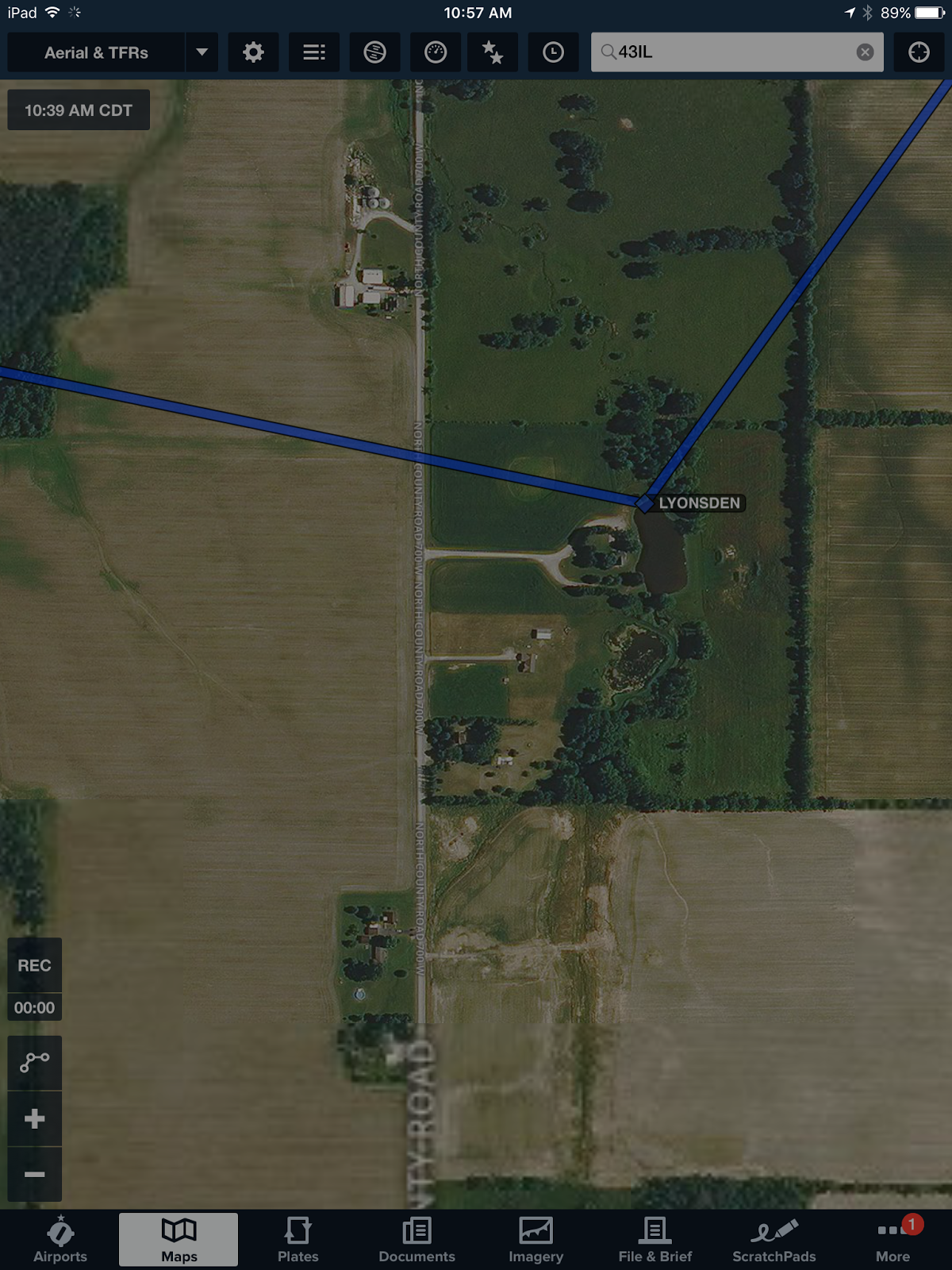
Lyons' Den (This is your fourth turn but you will call "Race XX Turn Seven")
Lyons' Den (This is your fourth turn but you will call "Race XX Turn Seven")
39.78026N
86.65873W
Outbound heading 039

86.65873W
Outbound heading 039
Turn 8 - 122.8
6I4 Boone County AirportHead north-northeast to just north of the northern most T-Hangars at Boone County Airport (6I4). You must be at or above 2,500' for this turn point - stay above their traffic pattern. ALL racers will call this Turn 8 over the radio.
40.00646N
86.43936W
Outbound heading 081


FINISH - 123.05
KTYQ Indy Executive Airport
40.03112N
86.25090W
Make a Two-Mile to Finish Call
and a Finish Call
After crossing the Finish Line, enter Left Traffic to land on the runway in use. If you need to cool down first, extend to the east and then re-enter.
After all racers are recovered there will be lunch and awards, and a candy drop for the Downs Syndrome Indiana families. We hope you will choose to participate in dropping candy after the race.
Here are some helpful tips for creating User Waypoints in ForeFlight -
The screen shots below are from the Standard Course, but the instructions are the same.
I start by entering airport IDs in the Search Bar, then once my general race route is created I select the Aerial Map to get a good look at the turn point, then drag the magenta line there and save the Lat/Lon with a Name and Description. This is called "rubberbanding" and pulls the magenta line to the exact spots for each turn point, saving the Lat/Lon in place of the airport ID.

After I've created all my User Waypoints, saved and named them, I create a Route in the NavLog in Edit Mode.

Then, I "Favorite" (save) the Route by tapping the single star that is to the right of the suitcase (Pack) icon. I named this one INDYAIRRACE2016. This makes it available in my Favorites so I can get to it any time by tapping the **double stars** at the very top, about the middle.

40.03112N
86.25090W
Make a Two-Mile to Finish Call
and a Finish Call
After crossing the Finish Line, enter Left Traffic to land on the runway in use. If you need to cool down first, extend to the east and then re-enter.
After all racers are recovered there will be lunch and awards, and a candy drop for the Downs Syndrome Indiana families. We hope you will choose to participate in dropping candy after the race.
Here are some helpful tips for creating User Waypoints in ForeFlight -
The screen shots below are from the Standard Course, but the instructions are the same.
I start by entering airport IDs in the Search Bar, then once my general race route is created I select the Aerial Map to get a good look at the turn point, then drag the magenta line there and save the Lat/Lon with a Name and Description. This is called "rubberbanding" and pulls the magenta line to the exact spots for each turn point, saving the Lat/Lon in place of the airport ID.


No comments:
Post a Comment